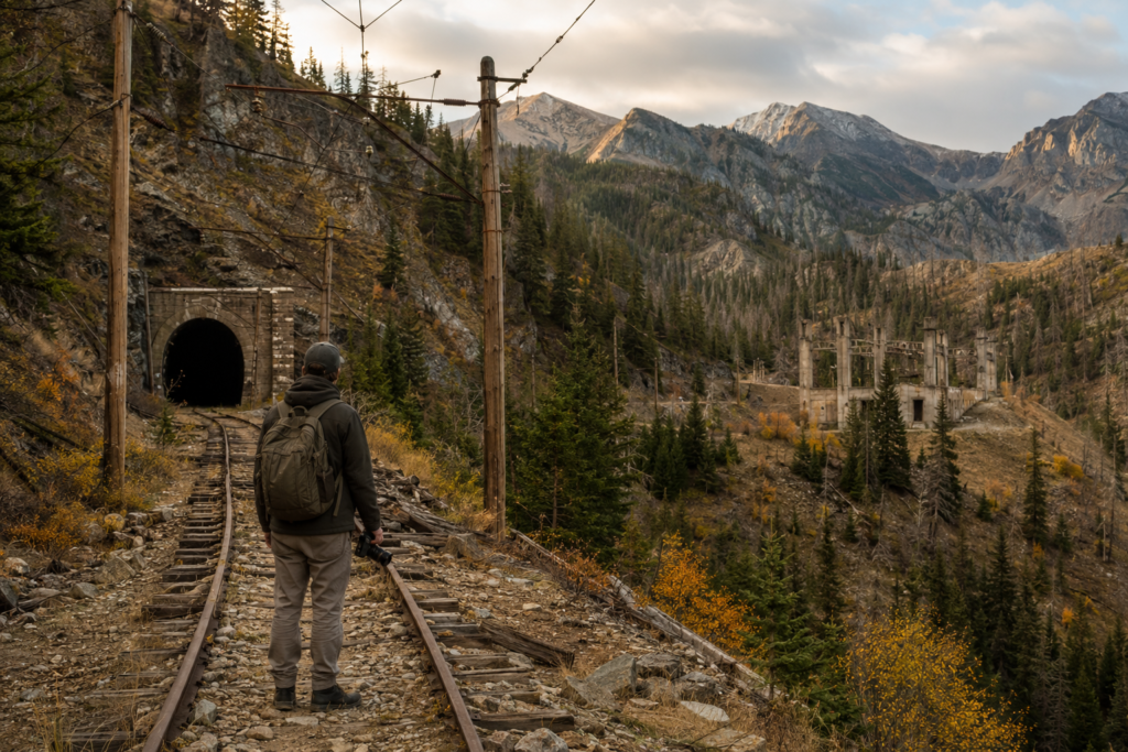
Across Montana’s mountains and empty valleys, the Milwaukee Road Montana abandoned routes preserve the remains of one of America’s boldest railroad experiments. Concrete electrical substations stand roofless beside fading grades, tunnel portals open into darkness, and bridge piers mark places where electric locomotives once hauled freight across the Continental Divide.
Officially known as the Chicago, Milwaukee, St. Paul and Pacific Railroad, the Milwaukee Road built farther west than almost any railroad of its era dared. Its Pacific Coast Extension became famous not only for reaching Puget Sound but also for using a pioneering 3,000-volt direct-current electrification system through some of the most difficult terrain in the American West.
The line’s abandonment in 1980 transformed a major transportation corridor into a chain of trails, ghost towns, industrial ruins, and isolated engineering landmarks.
Building the Pacific Coast Extension Across Montana
By the beginning of the twentieth century, the Milwaukee Road already controlled an extensive rail network in the Midwest. Its executives wanted direct access to Pacific ports, western timber, agricultural markets, and growing communities across the northern United States.
Construction of the Pacific Coast Extension began in 1906. Crews pushed west from South Dakota through Montana, Idaho, and Washington, ultimately reaching Tacoma and Seattle. Regular through service began in 1909.
The Montana portion crossed open prairie, river valleys, deep canyons, and two major mountain barriers. From the eastern plains, trains traveled through Miles City, Roundup, and Harlowton before turning toward the rugged center of the state.
This ambitious expansion became a defining chapter in Montana railroad history. It created new shipping opportunities for farmers and ranchers while connecting isolated mining, logging, and agricultural districts to national markets.
The speed of construction came at an enormous financial cost. The company had to purchase land, drive tunnels, build steel bridges, establish terminals, and maintain a long route through sparsely populated territory. These expenses would follow the railroad for decades.
Why the Milwaukee Road Electrified Its Mountain Line
Steam locomotives struggled on the steep grades and long mountain climbs west of Harlowton. They consumed large quantities of coal and water, produced smoke inside tunnels, and required significant maintenance.
The Milwaukee Road responded with technology that was remarkably advanced for the 1910s.
Beginning in 1915, the company electrified its Rocky Mountain territory using a 3,000V DC overhead system. Electricity reached locomotives through catenary wires suspended above the tracks. Substations positioned along the route converted high-voltage alternating current into the direct current required by the locomotives.
The first major electrified section ran from Harlowton to Deer Lodge. By 1917, electric operation had been extended west to Avery, Idaho, creating approximately 440 miles of electrified railroad across the Rocky Mountains.
A separate western electrified district was later developed between Othello and Tacoma in Washington. The section between Avery and Othello remained diesel or steam territory, leaving a substantial gap between the two electric districts.
For students of electric railway engineering, the Milwaukee Road remains fascinating because electrification was applied to heavy freight operations across wilderness rather than to a dense urban passenger network.
The Advantages of 3,000V DC Power
Electric locomotives offered several practical advantages in Montana’s mountain country:
- Strong pulling power at low speeds on steep grades
- Regenerative braking that returned electricity to the system
- Reduced smoke and heat inside tunnels
- Lower fuel requirements in electrified territory
- Reliable operation during severe winter conditions
- Fewer stops for water and coal than steam locomotives required
Regenerative braking was especially valuable. When descending mountain grades, electric locomotives could function as generators, feeding power back into the electrical system. Another train climbing elsewhere in the district could use some of that recovered energy.
Key Segments of the Milwaukee Road’s Western Route
The Pacific Coast Extension was not a single uniform landscape. Each operating district presented different geographic and engineering challenges.
Harlowton to Deer Lodge
Harlowton became the eastern gateway to the Rocky Mountain electrification. Its yards, roundhouse, and electrical facilities made the town an important Milwaukee Road center.
Westbound trains climbed through central Montana toward the Belt Mountains and the Continental Divide. The route passed through places such as Loweth, Ringling, and Three Forks before entering increasingly difficult country.
Deer Lodge developed into another major operating point, with railroad shops and crew facilities supporting the electrified line. Much of its identity became tied to the Milwaukee Road and the workers who maintained its locomotives.
Deer Lodge to Avery
West of Deer Lodge, the railroad faced some of its most dramatic terrain. Trains crossed Pipestone Pass, continued through western Montana, and approached the Bitterroot Mountains near the Idaho border.
The line passed Missoula and followed river corridors toward Alberton, Superior, and St. Regis. Beyond St. Regis, it climbed toward the summit tunnels before descending to Avery.
This portion contains many of the most visually compelling historic Montana train routes. Rock cuts, abandoned grades, tunnel entrances, and surviving catenary supports reveal how closely the railroad had to follow the terrain.
Avery to Snoqualmie and Puget Sound
Avery marked the western end of the Rocky Mountain electrified district. From there, the Pacific Coast Extension crossed Idaho and eastern Washington before reaching the Cascade Mountains.
Trains climbed over Snoqualmie Pass on the final approach to Seattle and Tacoma. Although Snoqualmie lies far beyond Montana, it represented the western mountain gateway of the same transcontinental route.
The Milwaukee Road’s journey from Harlowton through Avery and onward across Snoqualmie connected Montana’s electric railroad territory with Pacific Coast ports. This gave the company a direct route for grain, lumber, manufactured goods, and passenger traffic.
Pipestone Pass and the Continental Divide
Pipestone Pass was one of the defining landmarks of Milwaukee Road operations in Montana. Located southeast of Butte, the crossing carried the railroad across the Continental Divide at an elevation of more than 6,000 feet.
Rather than following a broad, gentle valley, engineers had to fit the railway into steep mountain terrain. The route included sharp curves, heavy grades, cuts, fills, and a tunnel approximately 2,300 feet long beneath the summit area.
Electric locomotives were well suited to this environment. They could apply consistent power while climbing and control heavy trains more effectively on the descent.
Today, the Pipestone Pass grade remains an evocative destination for people interested in abandoned railroad corridors. The landscape still displays the physical logic of the railway: curves follow the contours, embankments cross drainage channels, and old structures appear unexpectedly among trees and exposed rock.
Little Joe Locomotives on the Montana Main Line
Few locomotives are more closely associated with the Milwaukee Road’s electrified era than the Little Joes.
General Electric originally built these large electric locomotives for export to the Soviet Union. Cold War restrictions prevented their delivery, leaving the manufacturer with a group of powerful machines designed for heavy railway service.
The Milwaukee Road purchased 12 of them in 1950. Their nickname referred to Soviet leader Joseph Stalin, although the locomotives ultimately became icons of American railroading.
On the Milwaukee Road, they were classified for freight and passenger duties and adapted to the company’s 3,000V DC system. Their long bodies, massive running gear, and distinctive appearance made them instantly recognizable.
Little Joes hauled freight across Montana’s mountain grades and occasionally handled passenger assignments. Their power proved especially useful on long trains moving through Pipestone Pass and western Montana.
They now occupy a special place within Milwaukee Road heritage because they represent both the technical success of electrification and the international circumstances that brought an unusual locomotive design to the American West.
Communities and Structures Left Along the Right-of-Way
The railroad created settlements, sustained local businesses, and provided employment across Montana. When trains disappeared, some communities lost their primary economic purpose.
Notable places and structures associated with the abandoned route include:
- Maudlow: Once a Milwaukee Road division point in Sixteen Mile Canyon, Maudlow declined after railroad operations ended. Abandoned buildings and foundations have made it one of Montana’s best-known railway ghost towns.
- Loweth: A small settlement connected to railroad operations and the electrification system. Its substation remains among the most recognizable industrial ruins along the line.
- Ringling: A ranching and railroad community that declined after rail service disappeared. Surviving structures preserve the atmosphere of an isolated Montana railway settlement.
- Pipestone Pass Tunnel: A key passage beneath the Continental Divide and a reminder of the engineering required to carry trains west of Butte.
- Taft Tunnel: Also known as the St. Paul Pass Tunnel, this approximately 1.7-mile tunnel crosses beneath the Montana–Idaho border and is now part of a celebrated recreational trail.
- Sixteen Mile Canyon: A spectacular section characterized by narrow canyon walls, bridge remains, rock cuts, and a winding right-of-way beside Sixteenmile Creek.
- Catenary supports and substations: Concrete foundations, steel poles, and substation shells survive at scattered locations, tracing the former electric network.
These locations help connect Montana rail ghost towns with the larger story of transportation, migration, and industrial decline.
Why the Electrified Line Disappeared
The Milwaukee Road’s electric system performed well, but the railroad surrounding it faced mounting problems. The Pacific Coast Extension had been expensive to build, while competition from the Great Northern, Northern Pacific, highways, and airlines placed pressure on revenue.
Management decisions also weakened the western operation. Deferred track maintenance produced slow orders and unreliable service. At the same time, the company committed to replacing electric locomotives with diesel power.
Electric operations ended in 1974. Much of the catenary system was removed, while substations and specialized infrastructure were retired. The decision remains controversial among rail historians because rising fuel costs soon undermined some of the expected savings from dieselization.
The Milwaukee Road entered bankruptcy in 1977. It did not simply vanish that year, but the bankruptcy accelerated plans to abandon its western network.
In March 1980, service over most of the Pacific Coast Extension ended. The abandonment severed the railroad west of Miles City and removed the Milwaukee Road from the Montana mountain corridor it had spent so heavily to build.
Rails were lifted, bridges were removed or transferred, and many railroad properties were sold. Towns that depended on train crews, maintenance shops, and freight traffic experienced an abrupt economic change.
Exploring the Milwaukee Road Montana Abandoned Routes Today
The former Pacific Coast Extension has not disappeared completely. Portions survive as local roads, private property, utility corridors, active rail segments, and recreational trails.
The best-known preserved section is the Route of the Hiawatha near the Montana–Idaho border. Visitors travel through long tunnels and across high trestles while following part of the former Milwaukee Road grade. The experience offers a vivid sense of the scale of the original mountain crossing.
Elsewhere, access is less formal. Photographers may find abandoned substations, bridge abutments, telegraph poles, cuts, and ballast beds. Some sites are remote, unstable, or located on private land, so exploration requires permission, preparation, and respect for posted restrictions.
The combination of industrial ruins and mountain scenery has made the corridor especially attractive for railroad photography in Montana. Weathered concrete and rusted steel stand against forests, grasslands, and snow-covered peaks, creating images that feel suspended between technological ambition and natural reclamation.
The Milwaukee Road Montana abandoned routes now form a fragmented historical landscape rather than a continuous railroad. Yet the line remains remarkably legible. Hikers can follow its curves, historians can study its surviving substations, and railfans can stand beneath tunnel portals where Little Joe locomotives once carried freight toward the Pacific.
What survives is more than an abandoned grade. It is the physical memory of a railroad that crossed the Continental Divide with electric power, connected isolated communities to distant markets, and attempted to reinvent transportation across the American West.


